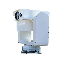


IR-EO Cameras & Systems Co., Ltd. is one of the most reliable manufacturers and suppliers of e380 advanced multi-purpose heavy-load eo/ir isrt system in China. Our factory offers high quality products made in China with competitive price. Welcome to contact us for customized service.
Conquer the toughest missions with the E380 EO/IR ISRT heavy load gimbal - the pinnacle of precision and power! At 37 kg, this advanced system integrates a EO camera (Visible light camera) , a cooled infrared thermal imager (TI Camera/ MWIR), a laser rangefinder (LRF), and a laser illuminator, offering all-weather capability, laser-guided strikes, and geographic tracking.
With advanced features like multi-target detection, image enhancement, and reduced operator workload, the 380A ensures mission success in reconnaissance, surveillance, and tactical operations for larger UAVs and manned aircraft.
Application Scenarios
Advanced missions: Reconnaissance, laser-guided strikes, damage assessment, and geographic tracking.
Platforms:
- Larger UAVs or manned aircraft,
- Land-system (Vehicle armored, RWCS, rooftop etc.),
- Marine (Unmanned or manned Vessel-borne, coastal etc.)
Parameter Table
|
Parameter |
Specification |
|
Gyro-stabilized Platform |
|
|
Weight |
|
|
- Gimbal |
≤ 37 kg |
|
Dimensions |
|
|
- Gimbal |
Φ 380 mm × 570 mm |
|
Range of Motion |
|
|
- Azimuth |
360° continuous |
|
- Pitch |
+20° to -110° |
|
Stabilization Accuracy |
≤ 25 µrad (RMS) |
|
Angular Measurement Accuracy |
≤ 1 mrad (RMS) |
|
Tracking Accuracy |
≤ 0.1 mrad (RMS) |
|
Target Positioning Accuracy |
Better than 30 m/5 km (CEP) |
|
Maximum Angular Velocity |
≥ 60°/s |
|
Maximum Angular Acceleration |
≥ 60°/s² |
|
Recording Time |
≥ 10 hours |
|
EO camera |
|
|
- Working Band |
0.4 µm to 0.9 µm |
|
- Resolution |
1920×1080 |
|
- Field of View (FOV) |
2°×1.1° to 36°×20.25° |
|
- Focal Length |
10 mm to 190 mm |
|
- Detection Range |
≥ 15 km |
|
- Recognition Range |
≥ 10 km |
|
TI camera |
|
|
- Detector |
Cooled MWIR MCT 640×512 |
|
- Working Band |
3 µm to 5 µm |
|
- Field of View (FOV) |
1.84°×1.48° to 35°×28° |
|
- Focal Length |
15 mm to 300 mm |
|
- Detection Range |
≥ 12 km |
|
- Recognition Range |
≥ 8 km |
|
Laser Range Finder |
|
|
- Range |
300 m to 20000 m |
|
- Accuracy |
≤ 5 m |
|
Laser Illuminator |
|
|
- Energy |
90/100/120 mJ (adjustable) |
|
- Beam Divergence |
≤ 0.2 mrad |
|
- Wavelength |
1.064 µm |
|
- Range |
≥ 5 km (for 4m×6m target, relative opening > 70%) |
|
Operating Modes |
|
|
- Modes |
Manual, Lock, Scan, Auto-Tracking |
|
Advanced Features |
|
|
- Target Detection |
Multi-target detection and alerts |
|
- Positioning |
Target positioning and geographic guidance using platform data |
|
- Image Processing |
Image enhancement for improved visibility |
|
Power Supply |
|
|
- Voltage |
28 VDC |
|
- Average Power |
≤ 200 W |
|
- Peak Power |
≤ 600 W |
|
Interfaces |
|
|
- Communication |
2× Async RS422 |
|
- Video |
1× Network, 1× HD-SDI |
|
Environmental Conditions |
|
|
- Operating Temperature |
-40°C to +60°C |
|
- Storage Temperature |
-50°C to +70°C |
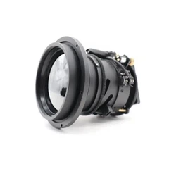
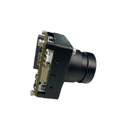
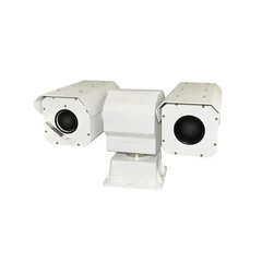
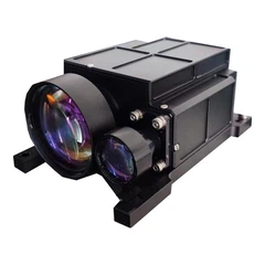
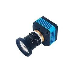
Product Pictures


3D model Dimensional Drawings
Functions and Features
- Battlefield Reconnaissance and Dynamic Target Surveillance: Enables real-time battlefield intelligence and target imagery updates, swiftly detecting, identifying, and tracking targets, with direct transmission of reconnaissance images to intelligence systems via digital networks.
- Laser Illumination and Guidance: Provides laser illumination for selected targets, guiding laser-guided missiles or bombs for precise strikes.
- Strike Effect Reconnaissance and Damage Assessment: Captures real-time imagery of target damage effects, transmitting strike assessment data directly to intelligence systems via digital networks.
- Geographic Tracking Capability: Features advanced geographic tracking for precise target location monitoring.
- Active and Passive Positioning: Supports both active and passive positioning with built-in local elevation data for high-precision positioning, including coordinate output and display for ground targets.
- Visible Light and Infrared Imaging with Quick Switching: Offers rapid switching between visible light and infrared imaging, simultaneous output of HD digital and analog images, all-weather capability, synchronized FOV adjustments, independent sensor power control (except visible light), and picture-in-picture functionality.
- Integrated Photo-Video Recording Visible Light Sensor: Outputs images via network/sync RS422 in PNG format, with a 1 KB memory buffer for user data caching (data format to be mutually agreed upon).
- Enhanced Imaging Features: Includes infrared enhancement, infrared pseudo-color, and visible light enhancement for superior image quality.
- Stable Target Tracking: Ensures stable tracking of static or dynamic targets, supporting manual and point-select tracking, with anti-jamming, anti-occlusion, over-the-top tracking, and decoupled tracking center from laser aiming line.
- Moving Target Detection: Detects moving ground targets with tracking assistance, accurately identifying and labeling targets for rapid tracking via assigned markers.
- Aerial Survey Mode with Platform Compensation: Features an aerial survey mode, compensating for platform roll disturbances to maintain a vertical view of the ground.
- Speed and Direction Measurement for Moving Targets: Provides speed and direction measurement capabilities for dynamic targets.
- Airtight Design with Nitrogen Purging: Ensures System hermetic and internal dryness of the optoelectronic system through nitrogen-filled airtight sealing.
- Near-Infrared Filter and Laser Spot Detection: Includes a near-infrared filter and laser spot detection capability for enhanced performance.
- Integrated Inertial Navigation: Offers high-precision attitude and position data, with the ability to use onboard inertial navigation as a backup and switch between internal and onboard data sources.
- High-Performance AI empowered platform: Integrates a high-performance computing module with expandable capabilities for video compression, multi-target recognition and tracking, image stitching, and support for landscape registration and visual navigation.
- Expert Menu and Health Monitoring: Features an expert menu with detailed health monitoring and fault diagnosis down to the board level for precise troubleshooting.
- Remote Program Upgrades: Supports program upgrades via network without requiring physical access to the device.
- Additional Features: Displays system status, laser pulse count statistics, and other operational data; includes rapid field optical axis calibration capability.
Hot Tags: e380 advanced multi-purpose heavy-load eo/ir isrt system, China, manufacturers, suppliers, factory, customized, made in China, 640 X 512 MCT Anti-shock MWIR Thermal Image Core, 640 High Resolution Long range Surveillance EO PTZ Systems, 384 X 288 Shutterless Uncooled LWIR Thermal Image Core, 640 VGA Shutterless Uncooled LWIR Thermal Image Core, infrared monitoring system, drone environmental monitoring eo ir gimbal